|
|
| Line 1: |
Line 1: |
| {{Status_alert|Ok! We got a map. Now we need names. Just put some names into a list in the Discussion page and we'll review it. If we see anything we like, we'll yank it out of there and use it in the game. And please, please try to come up with some decent names...!<br>
| |
| ::: <i><s>----</s> <u><b>[[User:Pauan|Pauan]] 12:55, 4 March 2007 (CET)</b></u></i>}}
| |
|
| |
| {{status_construction}}
| |
| ==the World Map==
| |
|
| |
| There will be no more starting over; this is the map. There will be inevitable but minor touchups over the course of development, (edges and other little things, to accommodate details in mapping) but we are close to being ready for more detailed work, based on this schematic. (Not just this single world overview, but closeups of specific regions and locations) Thanks to everyone's hard work and patience, we are finally (albeit gradually) getting back on track.
| |
|
| |
|
| |
| [[Image:WorldmapDevelopment.png]] | | [[Image:WorldmapDevelopment.png]] |
|
| |
|
| ===Areas===
| | ''These are the major areas of the world:'' |
| Names will be added as they are decided upon, as well information will be added/changed as it develops. Names will also be subject to trial durations; you may see something dubbed with a name and later, see it once again nameless. Sometimes you have to see a name in place for a bit, to realize it sounds stupid. We will avoid this at all costs, but it's bound to happen a few times until we're finally settled in.
| |
| | |
| '''LAND:'''
| |
| | |
| *[[C_Cont|Central Continent]]
| |
| | |
| *[[N_Cont|Northern Continent]]
| |
| | |
| *[[E_Cont|Eastern Continent]]
| |
| | |
| *[[Gasaro|Gasaro - the southern continent]]
| |
| | |
| *[[W_Isle|Western Islands]]
| |
| | |
| *[[Keshlam|Keshlam - the floating continent (islands, maybe?)]]
| |
| | |
| | |
| | |
| '''SEA:'''
| |
| | |
| | |
| | |
| ===Information Overlays===
| |
| | |
| The following information should be displayed on separate map overlays, either in a gallery format or in their own individual articles. I don't care which, so long as the information itself is adequately displayed and the categories of information are kept segregated. If you can display all of the necessary information with an image and no text, by all means, skip the article.
| |
| | |
| | |
| *''Elemental Flow'' - with the location of the four crystals as epicenters, like the other frame to that animated gif map.. the entire map could then be color-coded in that same manner. HOWEVER.. here is what we should do: overlap the elemental colors in the appropriate areas. This will show our false elemental areas in a believable manner. We can eventually do this color coding square-by-square.. especially once we begin to near an actual mapping phase.
| |
| | |
| *''Population Density'' - don't worry about racial color-coding.. we will have that information as a percentage in the articles for each region/location/etc.. we only care about where people live, so we can place towns and outskirts. A moderately-sized city should be able to fit in one whole grid-square, while a small town might fit in something as tiny as a quarter-square. It's something to keep in mind when making the density maps, because the solid clumps should not be much larger than a grid-square. Exceptions will be cultures who prefer to live with space between eachother.. such as the Earth-race in their tunnels, or the water race
| |
|
| |
|
| *''Political Boundaries'' - This could be merged with the population density map. It should stick to countries some of which may be more easily determined than others, we will not be able to complete this until we have a little more info on the whole of civilization laid out; micro-political boundaries (states and so forth) will be detailed in the articles for each country. | | ==Ancea - the ocean empire== |
| | *''the Tritan capital'' |
|
| |
|
| | ==Argaes - the central continent== |
| | *''the trade/capital city;'' '''new starting location''' |
| | *[[Sonbral]] |
| | *[[Zartam]] |
| | |
|
| |
|
| | ==Gasaro - the southern wilderness== |
| | *[[Issa]] |
|
| |
|
| ==Other Maps== | | ==Kaizei - the northern frontier== |
| | *[[Gloriana]] |
|
| |
|
| *''Underwater'' - this will give us a better opportunity to plan for more underwater exploration. I'd like to have more than one location underwater; it'd be GREAT to treat underwater as simply more explorable area, with a requirement to be there (the ability to breathe water, of course) The sea around circling the central continent should be like a cyclone
| | ==Keshlam - the floating islands== |
| | Before the Crystal of Air shattered, Keshlam was a normal part of the landscape. Now, it's northern face floats in and about the clouds, long detached from the land. The landbound people of [[Tempus]] live under the rule of the government of [[Nidostahn]]. Relationships are sour, but Tempus since is mostly a culture of unorganized intellectuals, philosophers & scientists, actual resistance to Nidostahn's rather unfair laws and taxation has been almost non-existent. |
|
| |
|
| *''Above the Clouds'' - Mostly for our floating continent (air) area. The tallest peak in the world should also be visible.
| | ==Tonori - the eastern desert== |
| | At one time, the land of Tonori was covered in dense jungle, but now it is a volcanic wasteland. When the Crystal of Fire shattered, the jungle's canopy burned & the majority of the vegetation quickly died thereafter. The people who remained in the desert somehow learned to flourish there, continuing their lineage in a place where no one expected it possible. Two kingdoms call Tonori home; [[Gispaa]] & [[Tulimshar]]. |
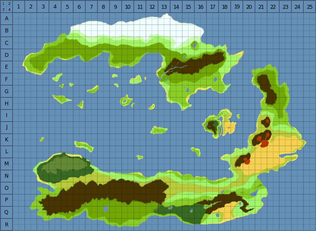
These are the major areas of the world:
Ancea - the ocean empire
Argaes - the central continent
Gasaro - the southern wilderness
Kaizei - the northern frontier
Keshlam - the floating islands
Before the Crystal of Air shattered, Keshlam was a normal part of the landscape. Now, it's northern face floats in and about the clouds, long detached from the land. The landbound people of Tempus live under the rule of the government of Nidostahn. Relationships are sour, but Tempus since is mostly a culture of unorganized intellectuals, philosophers & scientists, actual resistance to Nidostahn's rather unfair laws and taxation has been almost non-existent.
Tonori - the eastern desert
At one time, the land of Tonori was covered in dense jungle, but now it is a volcanic wasteland. When the Crystal of Fire shattered, the jungle's canopy burned & the majority of the vegetation quickly died thereafter. The people who remained in the desert somehow learned to flourish there, continuing their lineage in a place where no one expected it possible. Two kingdoms call Tonori home; Gispaa & Tulimshar.
