From The Mana World
Revision as of 19:36, 4 January 2012 by Crash demons (talk | contribs) (A labeled map of Hurnscald Outskirts (region highlighted))
No higher resolution available.
HurnscaldOutskirts_Labels.jpg (300 × 274 pixels, file size: 21 KB, MIME type: image/jpeg)
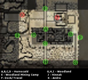
A labeled map of Hurnscald Outskirts (region highlighted)
File history
Click on a date/time to view the file as it appeared at that time.
| Date/Time | Thumbnail | Dimensions | User | Comment | |
|---|---|---|---|---|---|
| current | 19:36, 4 January 2012 | | 300 × 274 (21 KB) | Crash demons (talk | contribs) | A labeled map of Hurnscald Outskirts (region highlighted) |
You cannot overwrite this file.
File usage
There are no pages that use this file.